Featured Posts
Flag of Bangladesh
The national flag of Bangladesh was adopted officially on 17 January 1972..
Central Shohid Minar
The Shaheed Minar is a national monument in Dhaka, Bangladesh.
Jatiyo Smriti Soudho
The main structure and the artificial lake and other facilities were completed in 1982. It was Inaugurated at 16 December, 1982.
Jatiyo Sangshad Bhaban
Jatiyo Sangsad Bhaban or National Parliament House, is the house of the Parliament of Bangladesh, located at Sher-e-Bangla Nagar in the Bangladeshi capital of Dhaka.
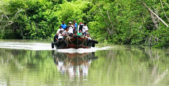
The Sundarbans
The Sundarbans is the largest single block of tidal halophytic mangrove forest in the world.[2] The Sunderbans is approximately 10,000 Sq Km of which 60% is located in Bangladesh.
Wednesday, October 7, 2015
Monday, August 4, 2014
All Information About Munshiganj District
Munshiganj also historically known as Bikrampur is
a district in central Bangladesh.
It is a part of the Dhaka Division and borders Dhaka
District.
Geography of Munshiganj District
Total land area is 235974 acres
(954 km²), out of which 138472 acres (560 km²) are cultivable and 5609 acres (23 km²)
are fallow land. It has no forest area. 40277 acres
(163 km²) of land is irrigated while 26242 acres
(106 km²) of land is under river. It has 14 rivers of 155 km passing
through.
Labels:
district,
Munshiganj District
All Information About Narsingdi District
Narsingdi is a district in central Bangladesh.It
is located 50 km
north-east of Dhaka, capital city of Bangladesh.
It is a part of the Dhaka Division, and is the only district in Bangladesh that
does not depend solely on agriculture. The district is famous for its textile
craft industry. Narsingdi is bordered by Kishoreganj in the north &
north-east, by Brahmanbaria in the east & south-east, Narayanganj at
south & south-west and by Gazipur in
the west.
Labels:
district,
Narsingdi District
All Information About Rajbari District
Rajbari ( Rajbari Jela also Rajbari Zila)
is a district in central Bangladesh. It is a part of the Dhaka
Division. It was named by the renowned ruler Raja Surjoprashad Sen. He
established his palace or rajbari in this district. It was a part of Faridpur district
before. Later on, it was separated from Faridpur and
rose as Rajbari.
Rajbari District Administration
Administrator of Zila Porishod: Akbar Ali Morji
Deputy Commissioner (DC): Md. Hasanuzzaman Kallol
Labels:
district,
Rajbari District
All Information About Netrakona District
Geography of Netrakona District
Netrakona is situated in the northern part of Bangladesh ,
near the Meghalayan border. There are four main rivers in Netrakona: Kangsha,
Dhala, Magra, and Teorkhali.
Netrakona Pouroshabha (Town of Netrakona ) is a municipal town, established
in 1887 and with an area of 13.63 km².
Labels:
district,
Netrakona District
All Information About Shariatpur District
Shariatpur (Shariatpur Jela also Shariatpur
Zila) is a district in the Dhaka
Division of central Bangladesh.
It is named after the eminent Islamic reformer Haji
Shariatullah.
History of Shariatpur District
Shariatpur was named after Haji
Shariatullah (1781–1840), who was the founder of Faraizi
Movement and an eminent Islamic reformer during British Raj.
Shariatpur was established as district on 1 March 1984. Earlier it was known as
Palong thana under Faridpur sub-division which was converted
to Shariatpur Sub-division and latterly as district with 6 upgraded thanas.
Labels:
district,
Shariatpur District
All Information About Sherpur District
Sherpur (Sherpur Jela also Sherpur Zila) is a
district in central Bangladesh. It is a part of the Dhaka
Division. Sherpur city is located about 198 km (123.03 mi ) north of Dhaka which is the capital of the country.
Subdivisions
There are 5 upazilas (sub-district) under this district,
namely:
Labels:
district,
Sherpur District
Subscribe to:
Posts (Atom)